Beyersville
aka Old Beyersville
Beyersville
Texas Historical Marker: no
- Primary Town: Beyersville
- Secondary Town(s): Taylor
- Cemetery Relocated to: no relocation
Historic Texas Cemetery Designation: no
- Williamson County Clerk Instrument Number: unknown
- Williamson Central Appraisal District Property ID: unknown

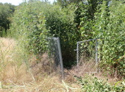
Beyersville Photo Courtesy John Christeson 2010

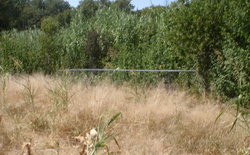
Beyersville Photo Courtesy John Christeson 2010
Notes:
WCHC’s Vol III, pg 71 per Clara Scarbrough & Mrs. Herman Riethmeyer Poldrack 1983 ”located on the N bank of Brushy Creek near Beyersville. Take FM 619 SE of Taylor, travel S toward Beyersville, but before crossing Brushy Creek, (3.6 miles S of the intersection of FM 619 & FM 112), turn left [probably should be “right”] near the old Wagon Wheel Tavern [in 2016: turn onto Wagon Wheel Rd], drive .3 mile to the edge of a field, then walk to the cemetery. The cemetery, which was originally near the village of Beyersville is 1-1/2 miles NW of present Beyersville (the second location to be called Beyersville, & this second one originally called ‘Happy Hill.’) The land for this cemetery was given by Gustav Beyer, pioneer settler there. At the original site, besides the cemetery, there was a school, store, gin & houses. In floods, some damage has been done to the cemetery, & numerous other graves are believed to be there.” [There is mention of different fencing around certain head stones.]
THC’s ATLAS: Driving Directions: From CR 451/FM 619 intersection in Beyersville, go 0.9 mile north on FM 619. Turn left onto Wagon Wheel Rd. and go 0.1 mile west. Stop just before sharp bend and dilapidated house on south side of road, and walk 453 ft. south and west to the far western edge of cultivated field. Partly fenced cemetery is located on the north bank of Brushy Creek and on east bank of deep drainage. This cemetery is highly endangered. It is a map feature, but is located on private property. No cemetery signs are posted. The cemetery is partly fenced and is not maintained. Many of the grave markers are fallen, displaced, or missing, and the cemetery is heavily overgrown with bamboo. Many of the graves are not clearly visible. A deep drainage runs along the western edge of the cemetery and may have significantly eroded a portion of the cemetery. There may be unmarked graves outside the fenced area as well. A large fieldstone and several wooden fence post may mark a grave plot just south of the fenced cemetery. The unfenced area is also overgrown with vinca and iris. The cemetery is highly threatened by erosion, flooding, nearby cultivation, and neglect.
Location is Approximate (1999 Map Information): (1999 mapped I5) Verified 9/28
Latitude: 30.51854000
Longitude: -97.34077000
485