Huddleston
Huddleston
Texas Historical Marker: no
- Primary Town: Leander
- Secondary Town(s): none
- Cemetery Relocated to: no relocation
Historic Texas Cemetery Designation: no
- Williamson County Clerk Instrument Number: 1998059224 & 191503530DR & 188416983DR
- Williamson Central Appraisal District Property ID: R031683

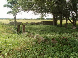
Huddleston Photo Courtesy John Christeson 2010

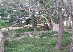
Huddleston Photo Courtesy John Christeson 2010

Huddleston Photo Courtesy John Christeson 2010
Notes:
Mapped per THC coordinates.
WCHC’s Vol I, pgs 151-151A per Myreta Matthews 1974..”about 1/2 mile off Bagdad Rd in the middle of a field on the Thelma Wells Lackey farm. About 2 miles N of FM 2243.”
WCHC’s Vol III, pg 349 (suppl p 17) in 1986 ”See Vol I for 1974 listing of this cemetery which at that time was on the Thelma Wells Lackey farm, in middle of a field, about 2 miles N of FM 2243 (off present – 1986 – CR 279-280). An earlier listing, published in the April 1961 issue of “Our Heritage”, The San Antonio Genealogical & Historical Society, gives additional information on this family cemetery. Listed by Mrs. L H. Williamson, a sister-in-law of Leona Williamson of Leander; submitted by Mrs. Charles Myler of San Antonio as follows: The plot is located in the extreme western part of Williamson County, about three miles W of Leander, which is situated on Hwy 183 N from Austin…All graves except one are enclosed within a 4-foot rock wall situated about 200 yards W of the road. A narrow lane leads to a tenant house where permission may be secured to enter the cemetery. The surrounding farm land is owned by Mrs. Lou Wells, a granddaughter of Thomas Huddleston, the original owner.”
Cemetery is in a grove of trees SW of the junction of Bagdad Road (CR 279) & CR 280. The ruins of the limestone cemetery fence can be seen from Bagdad Rd. Turn W on CR 280 & then S on the farm lane across from the farmhouse. Continue on the farm lane until you see the ruins of the limestone fence through the line of trees.
Location is Approximate (1999 Map Information): (1999 mapped B4) OK 9/13
Latitude: 30.59730309
Longitude: -97.88969202
420